Posts Tagged ‘mapping’
IRE and Esri fellowships awarded
IRE and Esri, the leading commercial publisher of geographic information system (GIS) software, have awarded 14 fellowships to attend Esri’s annual International User Conference and IRE’s mapping bootcamp. Fellowships to the User Conference this week in San Diego were awarded to: Dana Amihere, The Baltimore Sun Gus Begley, Houston Chronicle Wendy Fry, NBC 7-San Diego…
Read MoreIRE and Esri offering fellowships for mapping training
IRE and Esri have partnered to offer 10 fellowships to attend mapping training at the 2013 Esri International Users Conference from July 6-10 in San Diego and 3 fellowships to the IRE Mapping Boot Camp from August 9-11 at the University of Missouri-Columbia, Mo. The users conference fellowships cover airfare and four nights lodging, and the boot camp fellowships cover airfare and three nights lodging. The users…
Read MoreData journalism around the globe
Need a vacation but can’t imagine the outer darkness that is you without your work? Why not take it with you to exotic northern Europe. In “Data Journalism Around the Globe” panelists trotted out some of the best data projects coming from our cousins on the continent in the German, Danish and Scandinavian press. Many…
Read MorePasses for ArcView mapping sessions to be distributed Friday morning of CAR Conference
Those interested in taking the mapping classes (to qualify for the Esri ArcView software) at the 2013 CAR Conference must show up for the Friday morning session beginning at 7:30 a.m. at the Keeneland room. Slots in the class will be distributed until they are gone. If more than 24 people want to take the…
Read MoreBehind the Story: Post-Dispatch mapping finds ‘hot spots’ of pedestrian railroad deaths

Photo courtesy of the St. Louis Post-Dispatch. Photo courtesy of the St. Louis Post-Dispatch. In December, the St. Louis Post-Dispatch released Death on the Rails, a special report on the surprising number of pedestrian deaths that have occurred on railways. Reporter Todd Frankel explains how he cross-referenced databases and resources to build his own map…
Read MoreEsri offers free ArcGIS license to CAR Conference attendees
For those of you interested in getting started with mapping, we have great news: Esri is offering a free license to ArcGIS Desktop, a $1,500 value, for Louisville Conference attendees who attend the following four conference sessions: Friday, March 1 9 – 9:50 a.m. Mapping 1: Displaying data geographically (hands-on) 10 – 10:50 a.m. Mapping 2: Importing and selecting data…
Read MoreVote now for the NICAR 2013 T-shirt

Voting is now open in the NICAR 2013 T-shirt contest. We received more than 50 proposals for this year’s T-shirt, so voting will happen in two rounds: An initial round with all the proposals, and a second round of five finalists to choose the T-shirt design for the 2013 conference. Click here to see the proposals again. Look…
Read MoreCovering the tragedy in Newtown, CT
Shootings, especially those involving children and schools, devastate communities and garner unprecedented media coverage. But with the flood of media attention, reporters must remember those who were affected by the terrible events and take the necessary precautions while covering such a delicate story. In addition to the tipsheets and stories below, you can turn to…
Read MoreHurricane Sandy: How data journalists spread information about the storm
Google Crisis Response created this interactive map showing weather, emergency shelters and power authorities. As the East cost braced for Hurricane Sandy, data journalists across the country were working in realtime to spread the news. We gathered some of the interesting interactive coverage and data visualizations we found from around the web. Have a suggestion…
Read MoreBehind The Story: Analyzing and mapping salary data for small-town mayors
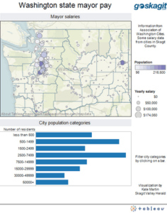
In August, reporter Kate Martin of the Skagit Valley Herald analyzed salary data for mayors across Washington state and ended up with a story about mayors from small towns in her coverage area — Mount Vernon and Anacortes — who had salaries on par with mayors from cities several times larger. In reporting the story,…
Read More